Physical Features of India Class 9 Questions and Answers Provided helps you to answer complex Questions too easily. You can use them while preparing for board exams and all of them are given by subject experts. Reading NCERT Solutions for Class 9 Social Science Geography Chapter 2 Physical Features of India familiarizes you with the kind of questions appearing in the board exams. Students are advised to read these solutions on a regular basis to score well.
Physical Features of India Class 9 Questions and Answers Geography Chapter 2
Make your learning experience enjoyable by preparing from the quick links available on this page. Use the Class 9 SST Geography Chapter 2 NCERT Solutions and get to know different concepts involved. All the Solutions are covered as per the latest syllabus guidelines. Knowing the NCERT Class 9 Geography Chapter 2 Questions and Answers helps students to attempt the exam with confidence.
Physical Features of India NCERT Intext Questions and Answers
Find out Textbook Page 11
Question 1.
The names of the glaciers and passes that lie in Great Himalayas.
Answer:
- Glaciers in the Great Himalayas: Gangotri, Chaturangi, Bhagirathi, Satopanth, Kamet, Milam and Pindari.
- Passes in the Great Himalayas: Karakoram pass, Shipkila pass, Nathula, Bumdila pass.
![]()
Question 2.
The name of the states where highest peaks are located.
Answer:
Mountain peaks States
- Kanchenjunga Sikkim
- Nanga Parbat Jammu and Kashmir
- Nanda Devi Uttarakhand
- Kamet Uttarakhand
- Namcha Barwa Assam
Question 3.
Location of Mussoorie, Nainital, Ranikhet from your atlas and also name the state where they are located.
Answer:
Mussoorie, Nainital and Ranikhet are located in Himachal Pradesh.
Geography Class 9 Chapter 2 NCERT Textbook Questions and Answers
Question 1.
Choose the right answer from the four alternatives given below:
(i) A landmass bounded by sea on three sides is referred to as
(a) Coast
(b) Island
(c) Peninsula
(d) None of the above
Answer:
(c) Peninsula
(ii) Mountain ranges in the eastern part of India forming its boundary with Myanmar are collectively called as
(a) Himachal
(b) Uttarakhand
(c) Purvachal
(cl) none of the above
Answer:
(c) Purvachal
![]()
(iii) The western coastal strip, south of Goa is referred to as;
(a) Coromandel
(b) Konkan
(c) Kannad
(d) Northern Circar
Answer:
(c) Kannad
(iv) The highest peak in the Eastern Ghats is
(a) Anai Mudi
(b) Kanchenjunga
(c) Mahendragiri
(d) Khasi
Answer:
(c) Mahendragiri
Question 2.
Answer the following questions briefly.
(i) What are tectonic plates?
(ii) Which continents of today were part of the Gondwana land?
(iii) What is the bhabarl
(iv) Name the three major divisions of the Himalayas from north to south.
(v) Which plateau lies between the Aravali and the Vindhyan ranges?
(vi) Name the island group of India having coral origin.
Answer:
(i) Large fragments of the Earth’s crust torn due to the rising currents are called tectonic plates.
(ii) South America, South Africa, part of Asia (India, Arabia, Malaya), Australia and Antarctica continents were parts of the Gondwana land.
(iii) The bhabar is that narrow belt of the plain which is covered with pebbles and lies along the foothills of the Shivaliks from the Indus to the Teesta.
(iv)
- The Great or Inner Himalayas or the Himadri.
- The Himachal or lesser Himalayas.
- The outer Himalayas or the Shivaliks.
(v) The Malwa Plateau lies between the Aravali and the Vindhyan ranges.
(vi) The Lakshadweep island group of India having coral origin.
![]()
Question 3.
Distinguish between
(i) Converging and Diverging tectonic plates
(ii) Bhangar and Khadar
(iii) Western Ghats and Eastern Ghats
Answer:
(i) Converging and Diverging tectonic plates
| Converging tectonic plates | Diverging tectonic plates |
| When tectonic plates move towards each other, they are called converging plates. | When tectonic plates move away from each other, they are called diverging plates. |
| In the event of two plates coming together they may either collide and crumble or one may slide under the other. | In the event of two plates moving away from each other they do not collide or crumble. |
| They cause folds. | They cause fractures in the crust. |
(ii) Bhangar and Khadar
| Bhangar | Khadar |
| These are the older alluvium and form the largest part of the northern plain. They lie above the flood plains of the rivers and presents a terrace like feature. They are less fertile. |
These are the newer and younger deposit of the floodplains. They lie next to a river. They contain calcareous deposits locally known as kankar. They are more fertile. |
(iii) Western Ghats and Eastern Ghats
| Western Ghats | Eastern Ghats |
| They lie along the Arabian sea.
They mark the western edge of the Deccan plateau. They are continuous and can be crossed through the passes only. They are higher than the Eastern Ghats. Their average elevation is 900-1600 metres. They cause orographic rain mostly in summer due to the summer monsoons. The climate is hot and moist. They have highly fertile soil, rice, spices, rubber, coconuts, cashew nuts, etc. are grown here. |
They lie along the Bay of Bengal.
They mark the eastern edge of the Deccan plateau. They are discontinuous, irregular and dissected by rivers draining into the Bay of Bengal. They are lower than the Western Ghats. Their average elevation is 600 metres. They cause rain mostly in winter through North-eastern monsoon. However, rain here is lesser than the western strip. They have less fertile soil. Rice, groundnuts, tabacco, cotton, etc. are grown here. |
![]()
Question 4.
Describe how the Himalayas were formed.
Answer:
(i) According to the theory of plate tectonics, the Earth’s crust was initially a single, huge super-continent called Pangea. Its northern part was the Angara land and the southern part was the Gondwana land.
(ii) The convectional currents split the crust into a number of pieces, thus leading to the drifting of the Indo-Australian plate after being separated from the Gondwana land, towards north.
(iii) The northward drift resulted in the collision of the plate with the much larger Eurasian plate. Due to this collision, the sedimentary rocks which were accumulated in the geosyncline known as the Tythes were folded to form the mountain system of western Asia and Himalaya.
Question 5.
Which are the major physiographic divisions of India? Contrast the relief of the Himalayan region with that of the Peninsular plateau.
Answer:
The major physiographic divisions of India are:
- The Himalayan Mountains
The Northern Plains - The Peninsular Plateau
- The Indian Desert
- The Coastal Plains
- The Islands
Contrast between the relief of the Himalayan region and the Peninsular plateau:
| The Himalayan region | The Peninsular Plateau |
| 1. The whole mountain system of Himalayas represents a very youthful topography with high peaks, deep valleys and fast flowing rivers. 2. From the view point of geology, this region forms an unstable zone. 3. The young fold mountains are made from the uplift of the strata formed by the sedimentary rocks. 4. It is the origin of perennial rivers. 5. The mountains ranges have I-shaped and U-shaped valleys. |
1. The peninsular plateau constitutes one of the ancient landmasses on the earth’s surface. It consists of broad and shallow valleys, and rounded hills. 2.This region is the most stable land blocks. 3.The Peninsular plateau is made of igneous and metamorphic rocks after splitting of Gondwana land. 4. It has rainfed seasonal rivers. 5. This region has horsts, rift valleys and troughs. |
Question 6.
Give an account of the Northern Plains of India.
Answer:
(i) The northern plains have been formed by the interplay of the three major river systems, namely the Indus, the Ganga and the Brahmaputra along with their tributaries.
(ii) These plains are formed of alluvial soil, which make these plains very fertile. With a rich soil cover combined with adequate water supply and favorable climate. It is agriculturally a very productive region of India. These features have attracted a huge population.
(iii) Between the mouths of the Indus and the Ganga-Brahmaputra, the Northern Indian Plain spreads over an area of 7 lakh square km. The plain is about 2400 km long and 240 to 320 km broad.
(iv) The Northern Plains have the Indus river system in the west and the Ganga-Brahmaputra river system in the east. The first includes Jhelum, Chenab, Ravi, Beas, Satluj. The Indus flows into the Arabian Sea. The second includes Ganga, its tributaries and the Brahmaputra which combine as Meghna as they drain into the bay of Bengal. They form the world’s largest and fastest growing delta.
(v) According to the variations in relief features, the Northern Plains are divided into four regions – bhabar, terai, bhangar and khadar. All the streams disappear in the bhabar belt. South to this belt the streams and rivers re-emerge and create a wet, swampy and marshy region called terai. Bhangar is old alluvial soil whereas khadar is newer, younger deposits of the flood plains.
![]()
Question 7.
Write short notes on the following:
(i) The Indian Desert
(ii) Central Highlands
(iii) The Islands groups of India
Answer:
(i) The Indian Desert: It lies towards the western margins of the Aravali Hills. It is an undulating sandy plain covered with sand dunes. This region receives very poor rainfall below 150 mm per year. It has dry climate with low vegetation cover. Streams appear only during the rainy season. Luni is the only large river in this region. Sand dunes are a common feature of the desert area.
(ii) The Central Highlands: The peninsular plateau consists of two broad divisions—the Central Highlands and the Deccan plateau. The part of the Peninsular plateau lying to the north of the Narmada river covering a major area of the Malwa plateau is called the Central Highlands. The Vindhyan range is bounded by the Central Highlands on the south and the Aravali range on the northwest. The flow of the rivers draining this region, namely the Chambal, the Sind, the Betwa and Ken is from southwest to northeast, thus indicating the slope. The Central Highlands are wider in the west but narrower in the east. The eastward extensions of this plateau are locally known as the Bundelkhand. The Chotanagpur plateau marks the further eastward extension, drained by the Damodar river.
(iii) The Island groups of India
India has two groups of islands:
- The Lakshadweep Islands group
- The Andaman and Nicobar Islands group
The Lakshadweep Islands group lie close to the Malabar coast of Kerala. This group of islands is composed of small coral islands. It covers small area of 32 sq km. Kavaratti island is its capital. This island group has great diversity of flora and fauna.
The Andaman and Nicobar islands group is an elongated chain of islands located in the Bay of Bengal extending from north to south. The entire groups of islands is divided into two broad categories—The Andaman in the north and the Nicobar in the south. These islands group is of great strategic importance for the country. A huge diversity of flora and fauna is found here. These islands lie close to equator and experience equatorial climate and has thick forest cover.
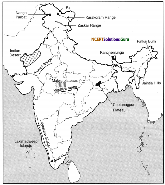
Map Skill
On an outline map of India show the following:
(i) Mountain and hill ranges—the Karakoram, the Zaskar, the Patkai Bum, the Jaintia, the Vindhya range, the Aravali, and the Cardamom hills.
(ii) Peaks—K2 Kanchenjunga, Nanga Parbat and the Anai Mudi.
(iii) Plateaus—Chotanagpur and Malwa.
(iv) The Indian desert, Western Ghats, Lakshadweep Islands.
Project/Activity
Locate the peaks, passes, ranges, plateaus, hills and duns hidden in the puzzle. Try to find where these features are located. You may start your search horizontally, vertically or diagonally.
Answer:
Do it yourself.
Hope the data shared above regarding the NCERT Class 9 Social Science Geography Chapter 2 Physical Features of India PDF has aided in your exam preparation. If you ever need any assistance you can always reach us and our team will guide you at the soonest possibility.