India Size and Location Class 9 Questions and Answers Provided helps you to answer complex Questions too easily. You can use them while preparing for board exams and all of them are given by subject experts. Reading NCERT Solutions for Class 9 Social Science Geography Chapter 1 India Size and Location familiarizes you with the kind of questions appearing in the board exams. Students are advised to read these solutions on a regular basis to score well.
India Size and Location Class 9 Questions and Answers Geography Chapter 1
Make your learning experience enjoyable by preparing from the quick links available on this page. Use the Class 9 SST Geography Chapter 1 NCERT Solutions and get to know different concepts involved. All the Solutions are covered as per the latest syllabus guidelines. Knowing the NCERT Class 9 Geography Chapter 1 Questions and Answers helps students to attempt the exam with confidence.
India Size and Location NCERT Intext Questions and Answers
Lets’s Discuss, NCERT Textbook Page 2
Question 1.
(i) Why 82°30′ E has been selected as the Standard Meridian of India?
(ii) Why is the difference between the durations of day and night hardly felt at Kanyakumari but not so in Kashmir?
Answer:
(i) 82°30′ E has been selected as the Standard Meridian of India because India has a wide east- west extent making it difficult to select the longitudes at the eastern or western ends a Standard Meridian as this would lead to serious discrepancies between the time followed and the sun’s position in the sky. To avoid such difficulty and to have a uniform time across the country 80°32′ E has been selected as the Standard Meridian as it passes through the middle of India reducing such differences.
(ii) As equator receivers direct sunlight, the duration between day and night would hardly be felt at Kanyakumari, on the other hand, Kashmir is at 37°N latitude, which means that it is 37 degrees away from the equator or it is 37 degrees away from the area which receives direct sunlight.
![]()
Lets’s Discuss, NCERT Textbook Page 4
(i) The number of Union Territories along the western and eastern coast.
(ii) Area-wise which is the smallest and which is the largest state?
(iii) The states which do not have an international border or lie on the coast.
(iv) Classify the states into four groups each having common frontiers with
(a) Pakistan
(b) China
(c) Myanmar and
(d) Bangladesh
Answer:
(i)
- Union Territories on the western coast are four in number: Daman and Diu, Dadra and Nagar
Haveli, Mahe (now Puducherry) and Lakshadweep. - Union Territories on the eastern coast of India are two in number: Pondicherry (now Puducherry) and Andaman & Nicobar Islands.
(ii)
- Goa is the smallest state.
- Rajasthan is the largest state.
(iii) The states which do not have an international border or lie on the coast are: Haryana, Madhya Pradesh, Chhattisgarh and Jharkhand.
(iv)
- States having common frontiers with Pakistan are: Jammu & Kashmir, Punjab, Rajasthan and Gujarat.
- States having common frontiers with Myanmar are: Jammu & Kashmir, Himachal Pradesh, Uttarakhand, Sikkim and Arunchal Pradesh.
- States having common frontiers with Myanmar are: Arunachal Pradesh, Nagaland, Manipur and Mizoram.
- States having common frontiers with Bangladesh are: West Bengal, Meghalaya, Assam and Tripura.
Geography Class 9 Chapter 1 NCERT Textbook Questions and Answers
Question 1.
Choose the right answer from the four alternatives given below:
(i) The Tropic of Cancer does not pass through
(a) Rajasthan
(b) Orissa (Now Odisha)
(c) Chhattisgarh
(d) Tripura
Answer:
(b) Orissa (Now Odisha)
![]()
(ii) The eastern most longitude of India is
(a) 97°25’E
(b) 68°7′ E
(c) 77°6’E
(d) 82°32’E
Answer:
(a) 97°25’E
(iii) Uttarakhand, Uttar Pradesh, Bihar, West Bengal and Sikkim have common frontiers with
(a) China
(b) Bhutan
(c) Nepal
(d) Myanmar
Answer:
(c) Nepal
![]()
(iv) If You intend to vistit Kavarati during your summer vacations, which one of the following Union Territories of India you will be going to?
(a) Puducherry
(b) Lakshadweep
(c) Andaman & Nicobar
(d) Diu and Daman
Answer:
(b) Lakshadweep
(v) My friend hails from a country which does not share land boundary with India. Identify the country.
(a) Bhutan
(b) Tajikistan
(c) Bangladesh
(d) Nepal
Answer:
(b) Tajikistan
![]()
Question 2.
Answer the following questions briefly.
(i) Name the group of islands lying in the Arabian Sea.
(ii) Name the countries which are larger than India.
(iii) Which island group of India lies to its south-east?
(iv) Which island countries are our southern neighbours?
Answer:
(i) Lakshadweep
(ii) Russia, Canada, USA, China, Brazil and Australia.
(iii) Andaman and Nicobar island group of India lies to its south-east.
(iv) Sri Lanka and Maldives are island countries and our southern neighbours.
Question 3.
The sun rises two hours earlier in Arunchal Pradesh as compared to Gujarat in the west but the watches show the same time. How does this happen?
Answer:
From Gujarat to Arunachal Pradesh there is a time lag of two hours. It means the sun rises two hours earlier in Arunachal Pradesh in the extreme east as compared to Gujarat in the extreme west. We know that the earth takes 4 minutes to rotate through 1° of longitude. So, the time taken by the earth to rotate through 15° longitude is 1 hour. Since India has a longitudinal extent of 30°, so there is a time difference of 2 hours between Arunachal Pradesh and Gujarat. But the watches show the same time because they are set for all parts of the country according to he Indian Standard Time (1ST) measured at 822° longitudes.
![]()
Question 4.
The Central location of India at the head of the Indian Ocean is considered of great significance. Why?
Answer:
The central location of India at the head of the Indian ocean is considered of great significance because of the following reasons:
(i) The Trans Indian Ocean routes which connect the countries of Europe in the west and the countries of East Asia provide a strategic central location to India.
(ii) The Deccan peninsula protrudes into the Indian Ocean helps India to establish close contact with West Asia, Africa and Europe from the western coast and with southwest and East Asia from the eastern coast.
(iii) No other country has a long coastline on the Indian Ocean as India has. It is India‘s eminent position in the Indian ocean which justifies the naming of an ocean after it.
Map Skills
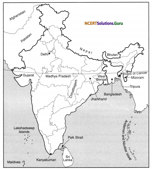
Question 1.
Identify the following with the help of map reading.
(i) The island groups of India in the Arabian Sea and the Bay of Bengal.
(ii) The countries constituting Indian Subcontinent.
(iii) The states through which the Tropic of Cancer passes.
(iv) The northernmost latitude in degrees.
(v) The southernmost latitude of the Indian mainland in degrees.
(vi) The eastern and the western most longitude in degrees.
(vii) The place situated on the three seas.
(viii) The strait separating Sri Lanka from India.
(ix) The Union Territories of India.
Answer:
(i) The Andaman and Nicobar islands lie in the Bay of Bengal and the Lakshadweep islands lie in the Arabian Sea.
(ii) Pakistan, Maldives, Nepal, Bhutan, Sri Lanka and Bangladesh.
(iii) Gujarat, Rajasthan, Madhya Pradesh, Chhattisgarh, Jharkhand, West Bengal, Tripura and Mizoram.
(iv) 37°6’N
(v) 8°4’N
(vi) 68°7′ E and 97°25′ E
(vii) Kanyakumari
(viii) Palk Strait
(ix) Andaman and Nicobar Islands, Chandigarh, Dadra and Nagar Haveli, Daman and Diu, Lakshadweep, Puducherry and Delhi.
![]()
Project/Activity
(i) Find out the longitudinal and latitudinal extent of your state.
(ii) Collect information about the ‘Silk Route’. Also find out the new developments, which are improving communication routes in the regions of high altitude.
Answer:
(i) Suppose my state is Uttar Pradesh. Its longitudinal and latitudinal extent are 11°A’ E to 84°39′ E and about 30°20′ N to about 23°53′ N respectively.
(ii)
- The Silk Route was an ancient network of trade routes that for centuries were central to cultural
interaction through regions of the Asian continent connecting the east and west from China to the Mediterranean Sea. - The Silk Route or road derives its name from the lucrative trade in Chinese silk carried out along its length, beginning during the Han dynasty.
- Trade on the Silk Route played a significant role in the development of the civilisations of China, the Indian subcontinent, Persia, Europe, the Horn of Africa and Arabia, opening the long-distance political and economic relations between the civilisations.
Hope the data shared above regarding the NCERT Class 9 Social Science Geography Chapter 1 India Size and Location PDF has aided in your exam preparation. If you ever need any assistance you can always reach us and our team will guide you at the soonest possibility.