Detailed, Step-by-Step NCERT Solutions for Class 12 Geography Chapter 6 Spatial Information Technology Questions and Answers were solved by Expert Teachers as per NCERT (CBSE) Book guidelines covering each topic in chapter to ensure complete preparation.
Spatial Information Technology NCERT Solutions for Class 12 Geography Chapter 6
Spatial Information Technology Questions and Answers Class 12 Geography Chapter 6
Question 1.
Choose the right answer from the four alternatives given below:
(i) The spatial data are characterised by the following forms of appearance.
(a) Positional
(b) Linear
(c) Areal
(d) All of the above
Answer:
(c) Areal
![]()
(ii) Which one of the following operations requires analysis module software?
(a) Data storage
(b) Data display
(c) Data output
(d) Buffering
Answer:
(b) Data display.
(iii) Which one of the following is a disadvantage of Raster data format?
(a) Simple data structure
(b) Easy and efficient overlaying
(c) Compatible with remote sensing imagery
(d) Difficult network analysis
Answer:
(d) Difficult network analysis
(iv) Which one of the following is an advantage of vector data format:
(a) Complex data structure
(b) Difficult overlay operations
(c) Lack of compability with remote sensing data
(d) Compact data structure
Answer:
(a) Complex data structure
![]()
(v) Urban change detection is effectively undertaken in GIS core using:
(a) Overlay operations
(b) Proximity analysis
(c) Network analysis
(d) Buffering
Answer:
(d) Buffering
Question 2.
Answer the following questions in about 30 words:
(i) Differentiate between raster and vector data models.
Answer:
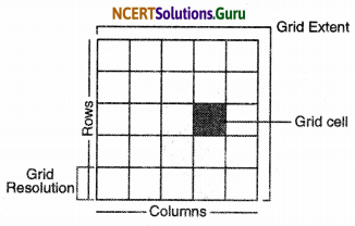
Raster Data Models. Raster data represents a graphic features as apattern of gird of squares a raster file would represent the image by sub-dividing the paper into a matrix of small rectangles similar to a sheet of graph paper.
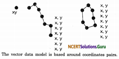
Vector Data Models. Vector data models represents the object as a set of lines drawn between specific points and vector data models representation of the same diagonal line would record the position of line by simple recording the coordinates of its starting and ending points.
![]()
(ii) What is an overlay analysis?
Answer:
An overlay operation is the hallmark of GIS. An integration of multiple layers of maps using overlay operations is an useful analysis function. In the other views GIS makes it possible to overlay two or more thematic layers of maps of the same area to obtain a new map layer. Map overlay can be used to learn the changes in land use over two different periods.
(iii) What are the advantages of GIS over manual methods?
Answer:
Advantages of GIS over manual methods are:
- Maps can be drawn by quering or analysing attribute data.
- Spatial operations can be applied on integrated data base to collect new sets of knowledge.
- Now with this users can interrogate spatial features displayed and retrieve associated attribute information for display and analysis.
- Different items of attribute data can be related with one another through shared locations code.
(iv) What are important components of GIS?
Answer:
The important components of GIS are as under:
- Hardware
- Software
- Data
- People
(v) What are different ways in which spatial data is built in GIS core?
Answer:
Different ways in which spatial data is built in GIS core are as under :
- Spatial data input
- Entering of the attribute data
- Data verification and editing
- Spatial and attribute data linkages
- Spatial analysis
![]()
(vi) What is Spatial Information Technology?
Answer:
Spatial word is derived from space. It refers to the features and the phenomona distributed over a geographically definable space, thus, having physically measurable dimensions. Data that we use today have some spatial components, like an address of a municipal facility, or the boundaries of a agricultural holdings etc. Spatial Information Technology relates to the use of the technological inputs in collecting, storage, retrieving, displaying, managing and analysing the spatial information.
Question 3.
Answer the following questions in about 125 words:
(i) Discuss raster and vector data formats. Give examples.
Answer:
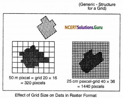
Graphic features are represented by raster data as a pattern of grids of squares where as vector data is helpful in representing the object as a set of lines drawn diagonally on a piece of paper. A raster file would represent this imagery subdividing the paper into a matrix of small rectangles similar to a sheet of paper called cells. Each cell is assigned aposition in the data file and given a value based on the attribute of that position. Its row and column coordinates may identify any individual pixel.
Vector Format: This representation of the same diagonal line would be record the position of the line by simply recording the coordinates of its starting and ending points. Each point would be expressed as two or three members depending on whether the representation was 2D or 3D often referred to as XY or XYZ coordinates.
(ii) Write an explanatory account of the sequence of activities of GIS related work.
Answer:
An explanatory account of the sequence of activities of GIS related work are as under:
1. Spatial data input. These could be summarised into the following two categories.
(a) Acquiring digital data site from a data supplies.
The present day data supplies make the digital data readily available which range from small scale map to the large scale maps.
(b) Creating digital data: manual input of data to a GIS involves four main stages:
- entering the spatial data
- entering the attribute data
- spatial and attribute data verification and editing.
The manual data input methods depend on whether the data base has a vector typology or grid cell.
2. Entering the attribute data. It defines the spatial entity that need to be handled in the GIS but which are not spatial.
3. Data verification and editing. This data captured into a GIS require verification for the error identification and corrections so as to ensure the data accuracy.
4. Linkage. GIS typically links different data sets. Suppose we want to know the mortality rate due to malnutrition among children under ten year of age in any state we must first combine or link the two. In one number of children of this age group another contains the mortality rate from malnitrition.
![]()