If you’re looking for a way to enhance your Social Science, then look no further than the NCERT MCQ Questions for Class 6 Geography Chapter 4 Maps with Answers Pdf free download. MCQ Questions for Class 6 Social Science with Answers is perfect for those who are in class 6 Geography and want to get ahead of everyone else by mastering their subject skills as soon as possible!
Maps Class 6 MCQs Questions with Answers
Solving MCQ on Maps Class 6 with Answers can be of great help to students as they will be aware of all the concepts. These Class 6 Geography Chapter 4 MCQ with Answers pave for a quick revision, thereby helping you learn more about this subject.
Question 1.
Which one is not a component of Map?
(i) Distance
(ii) Direction
(iii) Scale
(iv) Symbol
Answer
Answer: (iv) Symbol
Question 2.
When drawing a small area on a large scale is called:
(i) Plan
(ii) Map
(iii) Symbol
(iv) Sketch
Answer
Answer: (i) Plan
Question 3.
A large scale map is used to show:
(i) Small area
(ii) Large area
(iii) (i) & (ii) both
(iv) None
Answer
Answer: (i) Small area
Question 4.
A plan is a drawing of a small area on a:
(i) Small scale
(ii) Large scale
(iii) (i) & (ii) both
(iv) None
Answer
Answer: (ii) Large scale
Question 5.
Green colour is used for showing:
(i) Mountains
(ii) Plateaus
(iii) Plains
(iv) Waterbodies.
Answer
Answer: (iii) Plains
Question 6.
Topographical map are those
(a) Smaller than the atlas map
(b) Are used by engineers
(c) Larger than cadastral map
(d) Are based on actual survey of small area
Answer
Answer: (d) Are based on actual survey of small area
Question 7.
Symbol on map that represent human and physical features on surface of Earth is classified as
(a) Legend
(b) Grid
(c) Key
(d) Both a and c
Answer
Answer: (a) Legend
Question 8.
Which of the following is not the limitation of the globe
(a) Maximum distortion is seen in the region around the poles
(b) Represents earth on the flat surface
(c) Details are not given in the form of symbols
(d) Can study the detail part of the earth
Answer
Answer: (d) Can study the detail part of the earth
Question 9.
Atlas map are drawn on a ___________ scale.
(a) Infinite
(b) Small
(c) Very large
(d) Large
Answer
Answer: (b) Small
Question 10.
Plan is useful to show
(a) Details such as length and breadth of a room or place
(b) To find the location of place of the map
(c) Details of counties river, ocean
(d) Can be put together to make an Atlas
Answer
Answer: (a) Details such as length and breadth of a room or place
Question 11.
Which of the following is not among the cardinal direction
(a) South
(b) North-east
(c) East
(d) West
Answer
Answer: (b) North-east
Question 12.
Boundaries between different states are shown in __________ .
(a) Political Map
(b) Relief Map
(c) Vegetation
(d) Commercial Map
Answer
Answer: (a) Political Map
Question 13.
Usually top of the map indicates ___________ direction.
(a) West
(b) North
(c) South
(d) East
Answer
Answer: (b) North
Question 14.
Map showing the distribution of important crops, minerals, industries etc are called
(a) Distribution map
(b) Political map
(c) Divided map
(d) Physical map
Answer
Answer: (a) Distribution map
Question 15.
In map Light brown colour is used to show
(a) Rainfall
(b) Mountains
(c) Rivers
(d) Forest
Answer
Answer: (b) Mountains
Match the following
1.
| Column -I | Column-II |
| 1. Physical maps | (a) contain specific information – Roads, rainfall, forest, industries |
| 2. Political maps | (b) contain natural features of the earth |
| 3. Thematic maps | (c) showing small areas with detailed information. |
| 4. A small scale map | (d) Showing cities, countries, states, towns etc. |
| 5. A large scale map | (e) contain large areas — continent or countries |
Answer
Answer:
| Column -I | Column-II |
| 1. Physical maps | (b) contain natural features of the earth |
| 2. Political maps | (d) Showing cities, countries, states, towns etc. |
| 3. Thematic maps | (a) contain specific information – Roads, rainfall, forest, industries |
| 4. A small scale map | (e) contain large areas — continent or countries |
| 5. A large scale map | (c) showing small areas with detailed information. |
Fill in the blanks
1. A collection of map is called ……………………… .
(i) Symbol (ii) Atlas (iii) Scale (iv) Direction
Answer
Answer: (ii) Atlas
2. There are ……………………… components of Map.
(i) Three (ii) Four (iii) Five (iv) Six
Answer
Answer: (i) Three
3. A ……………………… is needed to represent a large distance.
(i) Symbol (ii) Atlas (iii) Scale (iv) Direction
Answer
Answer: (iii) three
4. There are ……………………… intermediate directions.
(i) one (ii) two (iii) three (iv) four
Answer
Answer: (iv) four
5. Conventional symbols are the universal symbols used in the map adopted by an ……………………… .
(i) Inter State Agreement (ii) National Agreement
(iii) bilateral agreement (iv) international agreement
Answer
Answer: (iv) international agreement
Picture Based Questions
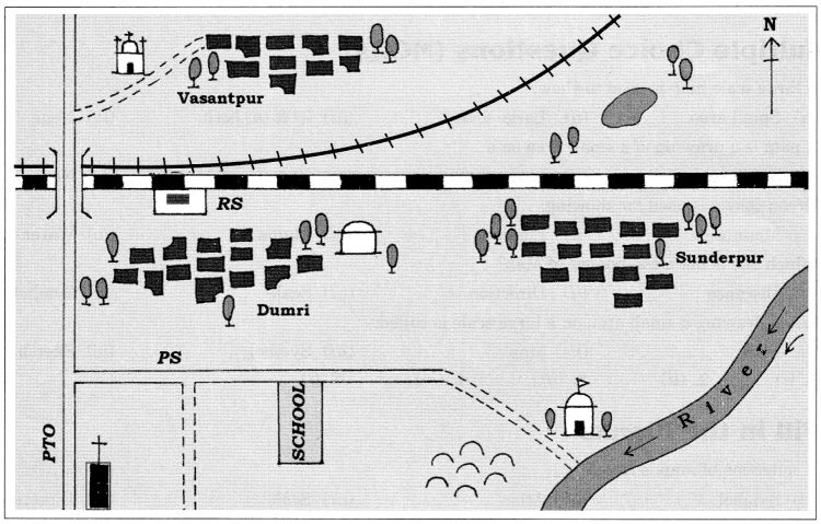
1. Look the picture given above and find out:
(i) In which direction is the river flowing?
(ii) What kind of road passes by the side of village Dumri?
(iii) On what type of railway line is Sunderpur situated?
(iv) On which side of the railway bridge is the police station situated?
(v) On which side of the railway line do the following lie?
(a) Chhatri (b) Church (c) Pond (d) Mosque
(e) River (f) Post and Telegraph Office (g) Graveyard
Answer
Answer:
(i) The river is following eastern to southern side.
(ii) Metalled Road
(iii) Broad Gauge
(iv) North side
(v) (a) South (b) South (c) North to the Broad gauge and south to the metre gauge
(d) North (e) South (f) South (g) South
2. Look the picture carefully given below and find out:
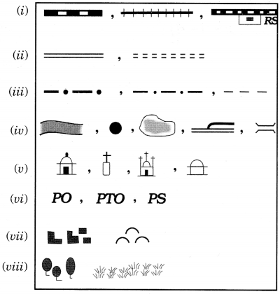
Answer
Answer:
(i) Railway Line: Broad gauge, Metre Guage, Railway sation
(ii) Roads: Metalled, Unmetalled
(iii) Boundary: International, State, District
(iv) River, Well, Tank, Canal, Bridge
(v) Temple, Church, Mosque, Chhatri
(vi) Post Office, Post and Telegraph Office, Police Station
(vii) Settlement, Graveyard
(viii) Trees, Grass
Hope you found this information on NCERT MCQ Questions for Class 6 Geography Chapter 4 Maps with Answers Pdf free download useful. We are always here to help, so if there is any specific query or question with CBSE Class 6 Social Science Maps Class 6 MCQs Multiple Choice Questions with Answers or any other topic please let us know in the comments below.